Hiking & Rock Climbing
You can hike for miles and miles through the River Valley region, encompassing major portions of the Ouachita National Forest and Ozark National Forest. Each of the three peaks feature hardy trails such as the Cedar Falls Trail and Seven Hollows Trail at Petit Jean State Park; the Cove Lake Trail System on Mount Magazine; and the Rim Trail atop Mount Nebo. Russellville hosts the popular Bona Dea Trails and wildlife sanctuary.
Biking
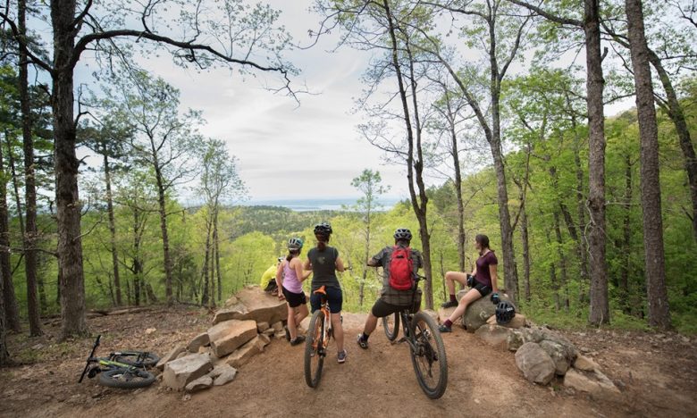
The Tri-Peaks region was made for great bike rides, on-road and off-road. Roar down rugged single-track trails or test your stamina on scenic roads ascending each of the three peaks. From the 28 mile Moccasin Gap Trail just off Scenic 7 Byway North near Dover, to the 34.3 mile Huckleberry Mountain Horse Trail—mountain bikers will find endless excitement in the Arkansas River Valley.
‘Bicycling Magazine’ named Arkansas’ Highest Peak at Mt. Magazine “The Climb to do in Arkansas.”
Motorcycling
Let your motorcycle be your chauffer to Arkansas’ highest peak at 2,753 feet on Mount Magazine/Wine County Loop which offers 10-miles of hairpin curves into earth’s natural décor. Embrace challenge on your ride through the Petit Jean Mountain Climb, a 145-mile loop to the top of Arkansas’ first state park.
The rolling landscape of the Arkansas River Valley leads to many exciting twists and turns across the hills and mountains where the Ozarks intersect with the Ouachitas. Just about any path you take will accelerate your imagination, but several rides are almost guaranteed to take your breath away—including the “Take Your Breath Away Run” down Scenic Highway 7 to Dardanelle past the beautiful Benedictine monastery at Subiaco and up to Mount Magazine State Park. Or take the “Bootlegger’s Trail” from Clarksville on Scenic Highway 21 and circling back on Highway 123 around the Ozark National Forest.
Directions to “Take Your Breath Away”:
Take Hwy 7 South to Dardanelle
Turn left on Jct 7/Hwy 22. Go .01 milesTurn right at on Hwy 27 and go 18.4 miles
Turn right on Hwy 10 at Danville and go 8.4 milesTurn right on Hwy 309 at Havana and stop for the breathtaking view!
Visit Mount Magazine State Park
Continue on Hwy 309 then turn right on Hwy 22 for 34 miles to Dardanelle
Turn left onto Hwy 7 back to Russellville
Directions for The Bootlegger’s Trail:
Leave from Clarksville on Scenic Hwy 21 and return via Hwy 123.
This scenic loop encompasses up to 100 miles of beautiful, breathtaking scenery of the Ozark National Forest.
Waterfalls, mountaintops, unique structures, and historic stops are just some of the features you’ll enjoy on this day-long trip.
Johnson County Regional Chamber of Commerce provides a milepost brochure and map of the entire trail for your convenience.
Camping
From cozy cabins to a tent beneath bright stars, you’ll find your place in the Tri-Peaks region!
In addition to the camping opportunities at each of the state parks, you can wake up to the sights and sounds of nature at Harris Brake Lake, Riverview Park, Horsehead Lake, Lake Overcup, and more.
Kayaking & Canoeing
Whether you prefer to gently float along or navigate extreme rapids, the Tri-Peaks region invites you to begin your adventure here! Marina boat rentals and outfitter services are available to get you on your way, connecting you with the majestic beauty found on our rivers and lakes.
Big Piney Creek
Rated Class I to III, with many advanced rapids to navigate.
Little Piney Creek
Rated Class I to II, moderate whitewater of incredible natural beauty.
Illinois Bayou
Rated Class II to III, it is recommended only for experienced canoeists.
Mulberry River
20+ significant Class I-III rapids to negotiate. An exhilarating experience!
Fishing
The Tri-Peaks region is home to waterways that abound with bass, bream, catfish, crappie and more.
From fishing off the banks surrounded by stunning scenic beauty to entering a bass fishing tournament below steep bluffs and tree-lined shores, the region offers adventure for all including two wheelchair-accessible fishing piers.


